Randonnée Marche La Chapelle-du-Mont-du-Chat - Le mont de la Charvaz - Photo
 sandrine-s01
sandrine-s01

Utilisateur

© OpenStreetMap contributors
Longueur
Longueur
11,9 km
Altitude max
Altitude max
944 m
Dénivelé positif
Dénivelé positif
321 m
Km-Effort
Km-Effort  
17,6 km
Altitude min
Altitude min
518 m
Dénivelé négatif
Dénivelé négatif
735 m
Boucle
Boucle
Non
Date de création :
2020-09-12 06:19:28.137
Dernière modification :
2020-09-12 10:24:13.007

(0 Avis)

Marche
Marche
4h03
Difficulté : Très facile

Scannez ce code QR pour ouvrir la randonnée dans l'application SityTrail

Application GPS de randonnée GRATUITE

Logo SityTrail SityTrail

IGN / Instituts géographiques

Télécharger SityTrail sur l'App Store Télécharger SityTrail sur Google Play

Logo SityTrail SityTrail World

Le monde est à vous

Télécharger SityTrail sur l'App Store Télécharger SityTrail sur Google Play Télécharger SityTrail sur Huawei AppGallery

À propos

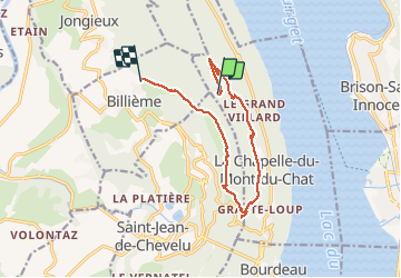
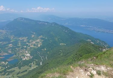
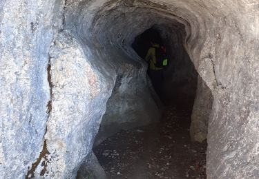
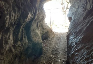
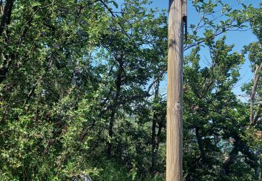
Randonnée Marche de 11,9 km à découvrir à Auvergne-Rhône-Alpes, Savoie, La Chapelle-du-Mont-du-Chat. Cette randonnée est proposée par sandrine-s01.

Profil altimétrique

Photos

Localisation

Pays :
France
Région :
Auvergne-Rhône-Alpes
Département/Province :
Savoie
Commune :
La Chapelle-du-Mont-du-Chat
Localité :
Unknown
Départ:(UTM)
720923 ; 5067033 (31T) N.

Randonnées à proximité

Randonnée Marche Brison-Saint-Innocent - La Croix de Meyrieu, retour par la Grotte des Fées, depuis les Combes - Photo
Marche
tracegps

Marche

Facile
(2)
Brison-Saint-Innocent, Auvergne-Rhône-Alpes, Savoie, France
8,5 km | 14,8 km-effort
3h 30min
Oui
Randonnée V.T.T. Aix-les-Bains - Randolac 2008 - Epine Chat Chambotte - Photo
V.T.T.
tracegps

V.T.T.

Très difficile
(1)
Aix-les-Bains, Auvergne-Rhône-Alpes, Savoie, France
64 km | 94 km-effort
7h 0min
Oui
Randonnée Marche Saint-Jean-de-Chevelu - La dent du chat - Photo
Marche
tippex01

Marche

Difficile
(1)
Saint-Jean-de-Chevelu, Auvergne-Rhône-Alpes, Savoie, France
3,1 km | 9,8 km-effort
1h 30min
Non
Randonnée Via ferrata La Chapelle-du-Mont-du-Chat - 2011-04-03 via ferrata Col du chat - Photo
Via ferrata
phschaefer

Via ferrata

Facile
(1)
La Chapelle-du-Mont-du-Chat, Auvergne-Rhône-Alpes, Savoie, France
3,6 km | 6,8 km-effort
Inconnu
Non
Randonnée Marche Saint-Jean-de-Chevelu - st jean le chevelu - Photo
Marche
loca.yves

Marche

Difficile
Saint-Jean-de-Chevelu, Auvergne-Rhône-Alpes, Savoie, France
15,4 km | 23 km-effort
6h 51min
Oui
Randonnée Marche La Chapelle-du-Mont-du-Chat - 270523 Tour et Dent du Chat - Photo
Marche
mzonzon05

Marche

Facile
La Chapelle-du-Mont-du-Chat, Auvergne-Rhône-Alpes, Savoie, France
10 km | 21 km-effort
4h 15min
Oui
Randonnée Marche Brison-Saint-Innocent - GROTTE AUX FEES-G2-19-09-22 - Photo
Marche
papou73

Marche

Moyen
Brison-Saint-Innocent, Auvergne-Rhône-Alpes, Savoie, France
5,6 km | 9,5 km-effort
2h 8min
Oui
Randonnée Marche Brison-Saint-Innocent - GROTTE AUX FEES-G1-19-09-22 - Photo
Marche
papou73

Marche

Difficile
Brison-Saint-Innocent, Auvergne-Rhône-Alpes, Savoie, France
7,7 km | 12,5 km-effort
2h 50min
Oui
Randonnée Marche La Chapelle-du-Mont-du-Chat - Le col du chat en savoie - Photo
Marche
colomb24

Marche

Très difficile
La Chapelle-du-Mont-du-Chat, Auvergne-Rhône-Alpes, Savoie, France
10,7 km | 22 km-effort
8h 57min
Oui


Fermer
Mes abonnements